


Geography
- Geographical situation in the continent
- Relief, landscape and vegetation
- Climate
- Regions, main cities and population
Geographical situation in the continent
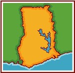
 | Ghana lies on the west coast of Africa. It is bordered on the north by Burkina Faso, on the west by Côte d’Ivoire, and on the east by Togo. The country lies just above the equator and is on the Greenwich meridian linewhich passes through the seaport of Tema, about 24 km to the east of Accra, the capital. With a total area of 238,537 square kilometers, Ghana is about the size of Britain. Its southernmost coast at Cape Three Points is 4° 30' north of the equator. From here, the country extends inland for some 670 kilometers. The distance across the widest part measures about 560 kilometers. |

Relief, landscape and vegetation
The terrain consists mostly low plains with the Kwahu Plateau in the south-central area. Half of the country lies less than 152 meters (500 ft) above sea level, and the highest point is 883 meters (2,900 ft). The 537 kilometer (334 mi) coastline is mostly a low, sandy shore backed by plains and scrub and intersected by several rivers and streams, most of which are navigable only by canoe. A tropical rain forest belt, broken by heavily forested hills and many streams and rivers, extends northward from the shore, near the Côte d'Ivoire frontier. This area, known as the "Ashanti," produces most of the country's cocoa, minerals, and timber. North of this belt, the country varies from 91 to 396 meters (300 to 1,300 ft) above sea level and is covered by low bush, park-like savanna, and grassy plains.
 Ghana is characterized in general by low physical relief. The highest elevation in Ghana, Mount Afadjato in the Akwapim-Togo Ranges, rises only 880 meters above sea level.
There are, nonetheless, five distinct geographical regions. Low plains stretch across the southern part of the country. To their north lie three regions--the Ashanti Uplands, the Akwapim-Togo Ranges, and the Volta Basin. The fifth region, the high plains, occupies the northern and northwestern sector of the country. Like most West African countries, Ghana has no natural harbors. Because strong surf pounds the shoreline, two artificial harbors were built at Takoradi and Tema (the latter completed in 1961) to accommodate Ghana's shipping needs.
Lake
Volta, dominates Ghana’s south-eastern territory, and is the world’s
largest artificial lake. The lake was created when the Akosombo
hydro-electric dam was built in 1964. Ghana is drained by a large number of streams and rivers. In addition,
there are a number of coastal lagoons, the huge man-made Lake Volta,
and Lake Bosumtwi, southeast of Kumasi
and which has no outlet to the sea. In the wetter south and southwest
areas of Ghana, the river and stream pattern is denser, but in the area
north of the Kwahu Plateau, the pattern is much more open, making
access to water more difficult. Several streams and rivers also dry up
or experience reduced flow during the dry seasons of the year, while
flooding during the rainy seasons is common.
Climate
 The climate of Ghana is
tropical, but
temperatures vary with season and elevation. The north of the country differs greatly in climate from
the south.
The climate of Ghana is
tropical, but
temperatures vary with season and elevation. The north of the country differs greatly in climate from
the south.
Except in the north two rainy seasons occur, from April to July and from September to November. In the north the rainy season begins in April and lasts until September.
Annual rainfall ranges from about 1,100 mm (about 43 in) in the north to about 2,100 mm (about 83 in) in the southeast.
Southern Ghana is much wetter, has high temperatures all year round, and has a very short dry season. Lush forests and all kind of crops grow throughout the year. Farmers in the North struggle to grow anything during the long dry season.
The harmattan, a dry desert wind, blows from the northeast from December to March, lowering the humidity and creating hot days and cool nights in the north. In the south the effects of the harmattan are felt in January.
In most areas the
highest temperatures occur in March, the
lowest in August. The
average annual temperature is about 26oC (about
79oF).
Regions, main cities and population
Ghana's population is estimated at 25,5 million (estimation 2012), roughly ten percent of whom live in and around the capital city of Accra (~2,6 millions d'habitants). Other major urban centres include Kumasi, Sunyani, Dunkwa, Salaga, Elmina, Wa, Boltanga, Yendi, Tamale, Bawku, Cape Coast et Tema.
For political and administrative purposes, Ghana is divided into 10
regions : Western, Central, Greater Accra, Easter, Volta, Ashanti,
Brong-Ahafo, Northern, Upper West and Upper East.